

Easter looked more like Christmas across some parts of the United States, and for Americans hoping to put cold and snow in the rearview mirror, the wait will last a while longer. And once a pattern change that could usher in more widespread warmth across the Midwest and Northeast arrives, it could unfortunately spawn more frequent rounds of severe weather in portions of the country.
The cold weather that has taken root from the North Central states to the Northeast in recent days is due to a large southward dip in the jet stream associated with a shift in the polar vortex.
"Into next week, a lobe of the polar vortex will hang out over Hudson Bay, Canada," Paul Pastelok, AccuWeather's top long-range forecaster, said.
In this position, waves of cold air will have an easy route from northern Canada to the northern Plains, Midwest and Northeast. Even portions of the southern Plains and interior Southeast will have episodes of chilly conditions that bring the risk of frosts and freezes.
Since cold air will be more firmly entrenched across the northern tier, there will be opportunities for snow and the likelihood of snowfall for some locations that typically do not get much snow during the middle of April.
Just a touch of snow was enough to trigger multiple-vehicle pile-ups around Chicago during Wednesday morning, and a more general snowfall is forecast to extend from the central Rockies to a narrow swath of the Midwest and into the interior Northeast prior to the end of this week.
However, the wintry pattern won't become stuck for too long. AccuWeather meteorologists expect the cold weather pattern to ease up next week.
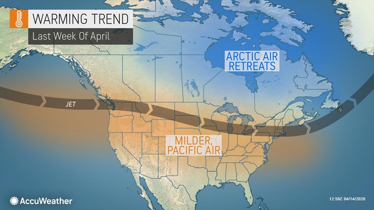
"During the fourth week of April (later next week), the polar vortex will retreat northward," Pastelok said.
"This shift will steer the coldest air away from the northern states and prevent future, big, long-lasting cold air invasions from northern Canada and will probably mark an end to snowy episodes in much of the Midwest and Northeast," Pastelok said.
The pattern will allow a fairly typical west to east jet stream set up from the Pacific coast to the Atlantic coast, meaning milder Pacific air will filter in across much of the country.
There will still be some bumps in the jet stream, associated with storm systems, at times during late April. However, these bumps would not tap into Arctic air, unlike the wintry pattern the nation is enduring now.
The normal temperature trend is increasing at a faster pace this time of year too. During April, average temperatures are climbing significantly with 1 degree Fahrenheit generally being added every two to three days in terms of highs and lows.
For example, at Chicago, the normal high on April 1 is 53 and the normal low is 34. By the end of April, the normal high is 65 and the normal low is 44. Even if temperatures just trend back to average late next week and replace the current below-average conditions, that temperature response in the forecast pattern could add 20 degrees or more to daytime highs and 10-20 degrees to nighttime lows.
Storm systems can lead to not only back-and-forth swings in temperatures but also the likelihood of thunderstorm outbreaks that can include severe weather episodes. Forecasters are already tracking the possibility of severe thunderstorms to erupt during the middle to latter part of next week.
"There is the potential that severe weather makes headlines around April 22 and 23 in the South," Pastelok said.
Pastelok also warned of another potential outbreak associated with an larger storm expected to eye the Central to Northeastern states prior to the end of April.
"A second severe outbreak is possible spanning April 27-29, which looks more widespread and farther north than the storms on April 22-23 and would impact areas from the middle Mississippi Valley to the East coast," Pastelok said.
This time in April is no stranger to severe weather. The notorious and deadly 2011 Super Tornado Outbreak occurred from April 25-28 when a multi-day round of dangerous storms claimed 321 lives across several states in the U.S.
Like 2011, 2020 has started off as an active year in terms of severe weather, and the 34 fatalities from last weekend's violent severe weather pushed 2020 ahead as the deadliest year for tornadoes since 2012, when 68 fatalities were blamed on twisters. As of Wednesday, 67 deaths in 2020 have been attributed to tornadoes. The extreme 2011 season brought a total of 553 deaths due to tornadoes, making it the second-deadliest year on record for the nation.
A substantial warmup is predicted to precede and accompany that late-month storm, helping to set the stage for severe weather. There could be some days where temperatures swing 10 degrees above average or greater, which may correspond to highs in the 70s and 80s in much of the Midwest and in part of the Northeast.
Warmth and thus severe weather occurrences are expected to be more widespread than normal for late April, even for this traditionally active time in severe weather season. On average, April yields the third-highest number of tornadoes of any month of the year, behind only May and June, and it is the deadliest month for twisters on average.
The reason behind the seasonal uptick in violent storms is the surge of warmth northward. The risk of severe weather often follows close behind building warmth and humidity.