WRIGHT COUNTY, Iowa — Thunderstorms rolled across much of central and northern Iowa Sunday evening into early Monday morning.
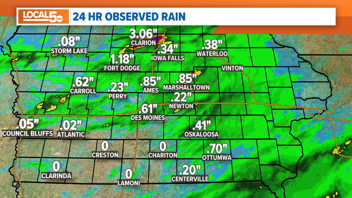
Rain totals were generally under 1” for most, but portions of Wright County saw persistent thunderstorms that pushed totals up into the 3-6” range.
That heavy rain over a short period caused flash flooding across Wright County. While waters are no longer rapidly rising, there are still areas of high water, inundated basements and local roads that are closed.
Please use caution as you head out travel in this area on Monday. A Flood Warning is in place through Monday afternoon.
RELATED: LOCAL 5 FORECAST
Most of that water over Wright County will drain into the Des Moines River north of Stratford. There will be a subtle rise to the river the next couple of days, but shouldn’t push the Des Moines River out of its banks.
While heavy, that rainfall was rather isolated in nature and won’t be enough to worry about filling Saylorville Reservoir downstream.


Here are the most recent rain totals from Sunday afternoon through Monday morning:
- Lake Cornelia: 5.5"
- Eagle Grove: 5.2"
- Clarion: 3.06"
- Harlan: 1.18"
- Fort Dodge: 1.18"
- Hampton: 0.94"
- Ames: 0.85"
- Marshalltown: 0.85"
- Ottumwa: 0.70"
- Norwalk: 0.68"
- Boone: 0.63"
- Carroll: 0.62"
- Des Moines International Airport: 0.61"
- Ankeny: 0.41"
- Oskaloosa: 0.41"
- Iowa Falls: 0.34"
- Pella: 0.3"
- Audubon: 0.28”
- Perry: 0.23”
- Newton: 0.22”
- Knoxville: 0.22”
- Cherokee: 0.21”
- Lamoni: 0.21”
- Centerville: 0.2”
- Algona: 0.11”
- Storm Lake: 0.08”
- Denison: 0.03”
- Atlantic: 0.02"

